Welcome to:
Mike's Photo Gallery!
Iceland Day 4
September 2015
Iceland Day 4, September 2015 Index
Iceland Day 4 001 - An entertaining storage shed across the street from our hotel in Hvammstangi
Iceland Day 4 002 - On Route 711, just North of Hvammstangi
Iceland Day 4 003 - Five miles North of Hvammstangi the asphalt ends
Iceland Day 4 004 - The Vatnsnes lighthouse seven miles North of Hvammstangi
Iceland Day 4 005 - We are in Strandir, ten miles North of Hvammstangi
Iceland Day 4 006 - Route 117 is a very scenic drive
Iceland Day 4 007 - No trees or tall bushes, just grass
Iceland Day 4 008 - The West coast of Miðfjörður fjord
Iceland Day 4 009 - Modern houses on Miðfjörður fjord
Iceland Day 4 010 - We have made it to the Northern end of the Vatnsnes peninsula
Iceland Day 4 011 - The Northern end of the Vatnsnes peninsula
Iceland Day 4 012 - Route 711 heads South on the Eastern side of the Vatnsnes peninsula
Iceland Day 4 013 - Walking trail at Hvitserkur
Iceland Day 4 014 - There is a hotel here, the Ósar HI Hostel
Iceland Day 4 015 - These are called Pink Footed Geese
Iceland Day 4 016 - The Hotel Borgarvirki on Route 711 one mile South of Sigríðarstaðavatn
Iceland Day 4 017 - Information about a local historical figure, a midwife named Rosa Gudmundsdottir
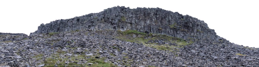
Iceland Day 4 018 - The rock formation ahead is called Borgarvirki
Iceland Day 4 019 - Walking trail to Borgarvirki
Iceland Day 4 020 - This little bird was having a grand time splashing around in the puddle
Iceland Day 4 021 - Interesting information signs can be found all around Iceland
Iceland Day 4 022 - Route 716 brought us back to the Ring Road
Iceland Day 4 023 - We made it to Blönduós
Iceland Day 4 024 - Time for lunch at the Potturinn Restaurant in Blönduós
Iceland Day 4 025 - Through some error we ended up returning South on Route 1
Iceland Day 4 026 - After our errant trip South we have now returned to Blönduós
Iceland Day 4 027 - Back in Blönduós it was time to stop at the N1 gas station for a car wash
Iceland Day 4 028 - A handy map of the Skaginn Peninisula at the beginning of Route 74
Iceland Day 4 029 - We are heading North on Route 74
Iceland Day 4 030 - We are now six miles up Route 74
Iceland Day 4 031 - About fourteen miles up Route 74 is the town of Skagaströnd
Iceland Day 4 032 - Short road leading to Skagabyggð
Iceland Day 4 033 - Looking West across Húnaflói Bay
Iceland Day 4 034 - Nobody here but us sheep
Iceland Day 4 035 - The Kálfshamarsvík peninsula
Iceland Day 4 036 - Approaching the Northwest corner of the Skagaheidhi Peninsula
Iceland Day 4 037 - Small island with an abundance of birds
Iceland Day 4 038 - At the Northeast corner of the Skagaheidhi Peninsula is the Skagatáarviti lighthouse
Iceland Day 4 039 - A few hills in the Hraun area
Iceland Day 4 040 - Sun shining on a farm in the Northeast area of the Skagaheidhi Peninsula
Iceland Day 4 041 - View of Skagafjörður fjord with Drangey Island in the distance
Iceland Day 4 042 - An old, long gone bridge
Iceland Day 4 043 - Church in Hvammur
Iceland Day 4 044 - The intersection with Route 744
Iceland Day 4 045 - Sheep roundup on Route 744
Iceland Day 4 046 - Route 744 is now heading back toward the coast
Iceland Day 4 047 - Approaching the large town of Sauðárkrókur
Iceland Day 4 048 - Obviously some delicious fish are near the surface of the water
Iceland Day 4 049 - Short rest stop in Sauðárkrókur
Iceland Day 4 050 - Intersection with Route 75
Iceland Day 4 051 - Intersection with Route 76 in Hofstadhir
Iceland Day 4 052 - Intersection with Route 769
Iceland Day 4 053 - The town of Hofsós, a trading port dating back to the 16th century
Iceland Day 4 054 - Þórðarhöfði
Iceland Day 4 055 - Classic looking Icelandic farm
Iceland Day 4 056 - East of Route 76 near Fell
Iceland Day 4 057 - Now we are getting toward the Northern section of the Trollaskagi Peninsula
Iceland Day 4 058 - Hiking trail up Reykjarholl hill
Iceland Day 4 059 - Information about Raven Floki and his three ravens
Iceland Day 4 060 - We are on Route 76 heading East near the intersection with 787
Iceland Day 4 061 - Picturesque area of Route 76 near the intersection with 789
Iceland Day 4 062 - We have reached the end of our journey on Route 76 and will now turn right (South) on 82
Iceland Day 4 063 - Lake Stífluvatn
Iceland Day 4 064 - At the Southern end of Lake Stífluvatn
Iceland Day 4 065 - This stream runs South out of Lake Stífluvatn
Iceland Day 4 066 - We are at 155 meters altitude and will be slowly descending as we head Northeast
Iceland Day 4 067 - Route 82 returns to sea level at Ólafsfjarðarvatn lagoon
Iceland Day 4 068 - The town up ahead is Ólafsfjörður, population 880
Iceland Day 4 069 - The main road in Ólafsfjörður is called Aðalgata
Iceland Day 4 070 - Route 82 leaves Ólafsfjörður heading Northeast for a short distance
Iceland Day 4 071 - We are in Upsir heading South on Route 82
Iceland Day 4 072 - Dalvik, population 1450
Iceland Day 4 073 - Information and a map are available as Route 82 heads South out of Dalvik
Iceland Day 4 074 - The town of Árskógssandur is on this patch of land
Iceland Day 4 075 - Route 82 continues South on the West coast of Eyjafjörður fjord
Iceland Day 4 076 - Möðruvellir is the town up ahead
Iceland Day 4 077 - We are back on the Ring Road
Iceland Day 4 078 - Entrance to our hotel, the Skjaldarvik Guest House
Iceland Day 4 079 - After checking in at the hotel we made the half mile trip back to the Ring Road
Iceland Day 4 080 - Subway shop at the corner of Glerárgata and Kaupvangsstræti in downtown Akureyri
Iceland Day 4 081 - Italian restaurant downtown
Iceland Day 4 082 - Air Iceland Fokker F50
Iceland Day 4 083 - Exploring the City Center area of Akureyri